Fichier:Le Castellet circuit map Formula One 2018 without corner names English 29 06 2021.svg

Le contenu de la page n’est pas pris en charge dans d’autres langues.
Une page de Wikipédia, l'encyclopédie libre.

Fichier d’origine(Fichier SVG, nominalement de 2 191 × 1 951 pixels, taille : 59 kio)

Ce fichier et sa description proviennent de Wikimedia Commons.

Description

Description
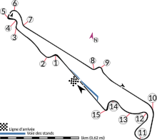
English: This is an altered version of File:Le Castellet circuit map Formula One 2018 without corner names June 2021.svg with the key solely in English and a few other alterations. This is a map of the Le Castellet motor circuit as it was used by w:en:Formula One for the w:en:2018 French Grand Prix, before the pit lane entrances and exits were reconfigured, and includes corner numbers and other information sourced from the FIA's map of the circuit. This map is valid for races which use this layout and corner numbering scheme, please upload a new file for races which use different layouts or corner numbering schemes rather than replacing this file. As this is a free-hand map drawn by an enthusiast rather than a professional cartographer's work it may contain some errors, although checking it against other maps it appears accurate enough for most purposes. The track is shown in black with a grey outline, while the pit lane is shown in blue. A scale showing the length of one kilometre (with increments of 100 metres) is given, to allow viewers to contextualise and understand what they are looking at. Corner numbers and other important text is given an off-white background to avoid transparency issues rendering it illegible on certain devices. A thick white line covering the track and the pit lane, marked with a chequered flag, shows the location of the start/finish line, also known as the control or timing line. A thinner white line, covering only the track, shows the location of pole position, and is marked with a large black arrow indicating the direction of travel. There are also thin white lines crossing the track which indicate the ends of the first and second timing sectors used by Formula One; these are marked with smaller black arrows, which also indicate the direction of travel. The mauve arrow marked "N" shows the direction of north.
 
Arrow pointing north
 
Pit lane
 
Links corner number to location of corner
Date
Source Travail personnel
Auteur HumanBodyPiloter5
Autres versions
The 2019 layout, after the pitlane was modified
Une version française
A version of the map with the key in multiple languages and other minor differences

Conditions d’utilisation

Moi, en tant que détenteur des droits d’auteur sur cette œuvre, je la publie sous la licence suivante :
Creative Commons CC-Zero Ce fichier est disponible selon les termes de la licence Creative Commons CC0 Don universel au domaine public.
La personne qui a associé une œuvre avec cet acte l’a placée dans le domaine public en renonçant mondialement à tous ses droits sur cette œuvre en vertu des lois relatives au droit d’auteur, ainsi qu’à tous les droits juridiques connexes et voisins qu’elle possédait sur l’œuvre, sans autre limite que celles imposées par la loi. Vous pouvez copier, modifier, distribuer et utiliser cette œuvre, y compris à des fins commerciales, sans qu’il soit nécessaire d’en demander la permission.

Légendes

Ajoutez en une ligne la description de ce que représente ce fichier
A map of the Le Castellet motor circuit as it was used by Formula One for the 2018 French Grand Prix

Éléments décrits dans ce fichier

dépeint

Valeur sans élément de Wikidata

Historique du fichier

Cliquer sur une date et heure pour voir le fichier tel qu'il était à ce moment-là.

Date et heureVignetteDimensionsUtilisateurCommentaire
actuel29 juin 2021 à 03:15Vignette pour la version du 29 juin 2021 à 03:152 191 × 1 951 (59 kio)HumanBodyPiloter5Uploaded own work with UploadWizard

La page suivante utilise ce fichier :

Usage global du fichier

Les autres wikis suivants utilisent ce fichier :

Métadonnées