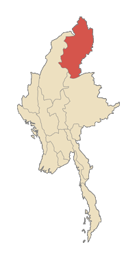
État kachin
| État de Kachin | |
|---|---|
| Fichier:Kachinstateflag.png | |
| Informations | |
| Capitale : | Myitkyina |
| Date de création : | 19 |
| Districts : | - voir texte. |
| Population - Totale (2005)
|
1 200 000 hab. 1,4 hab./km² |
| Superficie | 89 041 km² |
| PIB (2004) |
[[]] |
| Localisation | |

| |
| transcription = kahkyin-pi-nai | ethnic = Kachin, Bamar, Shan, Naga, Indians, Chinese | religious = Christianity, Buddhism,Islam, Hinduism
L'État de Kachin (Jingphaw Mungdaw, birman : ![]() ) est la plus septentrionale des subdivisions du Myanmar (Birmanie). Il est frontalier de la Chine au Nord et à l'Est, de l'État Shan au Sud et de la Division de Sagaing et de l'Inde à l'Ouest. Il se situe entre 23° 27' et 28° 25' de latitude nord et 96° 0' et 98° 44' de longitude est. Sa superficie est de 89041 km². Sa capitale est Myitkyina. L'autre ville importante est Bhamo.
) est la plus septentrionale des subdivisions du Myanmar (Birmanie). Il est frontalier de la Chine au Nord et à l'Est, de l'État Shan au Sud et de la Division de Sagaing et de l'Inde à l'Ouest. Il se situe entre 23° 27' et 28° 25' de latitude nord et 96° 0' et 98° 44' de longitude est. Sa superficie est de 89041 km². Sa capitale est Myitkyina. L'autre ville importante est Bhamo.
Dans l'État de Kachin se trouve la plus haute montagne de Birmanie, le Hkakabo Razi (5 889 m), formant la pointe sud de l'Himalaya, et le plus grand lac d'Asie du Sud-Est, le lac Indawgyi.
Population
Les 1,2 millions d'habitants sont d'ethnie Kachin (ou Jingpo), Rawang, Lisu, Zaiwa, Lawngwaw et Lachyit. L'état abrite aussi des birmans et des Shans. No census has been taken in almost a century. Official government statistics state that the distribution by religion is 57.8% Buddhist, 36.4% Christian. The Kachin language is the lingua franca in the State, and has a written version based on the Roman alphabet. [1]
Economy
The economy of Kachin State is predominantly agricultural. The main products include rice, sugar cane. Mineral products include gold and jade.
Education
| No. | District | Township | Elementary School | Middle School | High School | Total |
|---|---|---|---|---|---|---|
| 1 | Myitkyina | Myitkyina | 135 | 13 | 10 | 158 |
| 2 | Banmo | Banmo | 73 | 8 | 4 | 85 |
| No. | District | Township | University | Degree College | College | Total |
|---|---|---|---|---|---|---|
| 1 | Myitkyina | Myitkyina | 1 | 2 | 1 | 4 |
| 2 | Banmo | Banmo | 0 | 3 | 0 | 85 |
List of Universities, Degree Colleges and Colleges in Kachin State
- 1. Myitkyina University
- 2. Myitkyina Education College
- 3. Myitkyina Government Technical College
- 4. Myitkyina Government Computer College
- 5. Bhamo Degree College
- 6. Bhamo Government Computer College
- 7. Bhamo Degree Technical College
Health
| No. | District | Township | Special Hospital | General Hospital | Hospital under 100 beds | Total |
|---|---|---|---|---|---|---|
| 1 | Myitkyina | Myitkyina | 1 | 1 | 2 | 4 |
| 2 | Banmo | Banmo | 0 | 1 | 1 | 2 |
History
The Burmese government under Aung San reached the Panglong Agreement with the Shan, Kachin, and Chin peoples on 12 February, 1947. The agreement accepted "Full autonomy in internal administration for the Frontier Areas" in principle and envisioned the creation of a Kachin State by the Constituent Assembly. Kachin State was formed in 1948 out of the British Burma civil districts of Bhamo and Myitkyina, together with the larger northern district of Puta-o. The vast mountainous hinterlands are predominantly Kachin, whereas the more densely populated railway corridor and southern valleys are mostly Shan and Bamar. The northern frontier was not demarcated and until the 1960s Chinese governments had claimed all of Kachin State as Chinese territory since the 18th century. Before the British rule, roughly 75% of all Kachin jadeite ended up in China, where it was prized much more highly that the local Chinese nephrite.
Kachin troops formerly formed a significant part of the Burmese army. With the unilateral abrogation of the Union of Burma constitution by the Ne Win regime in 1962, Kachin forces withdrew and formed the Kachin Independence Army (KIA) under the Kachin Independence Organization (KIO). Aside from the major towns and railway corridor, Kachin State has been virtually independent from the mid 1960s through 1994, with an economy based on smuggling, jade trade with China and narcotics. After a Myanmar army offensive in 1994 seized the jade mines from the KIO, a peace treaty was signed, permitting continued KIO effective control of most of the State, under aegis of the Myanmar military. This ceasefire immediately resulted in the creation of numerous splinter factions from the KIO and KIA of groups opposed to the peace accord, and the political landscape remains highly unstable.
Traditional Kachin society was based on shifting hill agriculture. Political authority was based on chieftains who depended on support from immediate kinsmen. Considerable attention has been given by anthropologists of the Kachin custom of maternal cousin marriage, wherein it is permissible for a man to marry his mother’s brother’s daughter, but not with the father’s sister’s daughter. Traditional religion was animist, but missionary activity since the British period have converted the vast majority of the population to Christianity (notably Baptist and pockets of Roman Catholicism).
See also
External links
- Kachin National Organization
- The Kachin Post
- KIO News in English
- News in Jingphaw, English and Burmese
- World's End in Kachin State Wofgang H Trost, The Irrawaddy, July 1, 2007

