
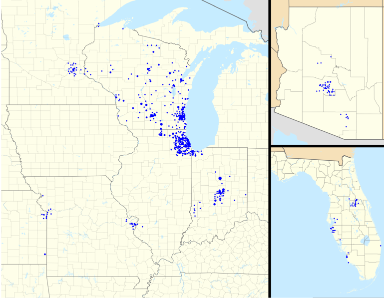
Fichier:BMO Harris Bank 2012-06.png

Taille de cet aperçu : 769 × 599 pixels. Autres résolutions : 308 × 240 pixels | 616 × 480 pixels | 986 × 768 pixels | 1 280 × 998 pixels | 2 560 × 1 995 pixels | 3 811 × 2 970 pixels.
Fichier d’origine (3 811 × 2 970 pixels, taille du fichier : 1,44 Mio, type MIME : image/png)
Ce fichier et sa description proviennent de Wikimedia Commons.
Description


|
|
Point Maps
══▻ FAQ ◅══ ══▻ Create your own ◅══ |
Conditions d’utilisation
Ce fichier est disponible selon les termes de la licence Creative Commons Attribution – Partage dans les Mêmes Conditions 3.0 (non transposée).
- Vous êtes libre :
- de partager – de copier, distribuer et transmettre cette œuvre
- d’adapter – de modifier cette œuvre
- Sous les conditions suivantes :
- paternité – Vous devez donner les informations appropriées concernant l'auteur, fournir un lien vers la licence et indiquer si des modifications ont été faites. Vous pouvez faire cela par tout moyen raisonnable, mais en aucune façon suggérant que l’auteur vous soutient ou approuve l’utilisation que vous en faites.
- partage à l’identique – Si vous modifiez, transformez, ou vous basez sur cette œuvre, vous devez distribuer votre contribution sous la même licence ou une licence compatible avec celle de l’original.
Journal des téléversements d’origine
This image is a derivative work of the following images:
- File:USA_location_map_-_counties.svg licensed with Cc-by-sa-3.0
- 2012-02-04T01:39:12Z Magog the Ogre 13310x6935 (11174733 Bytes) =={{int:filedesc}}== {{Information |description={{de|Positionskarte der [[:de:Vereinigte Staaten|Vereinigten Staaten]] („lower 48“)}} Quadratische Plattkarte, N-S-Streckung 120 %. Geographische Begrenzung der Karte: * N:
- File:Canada Ontario location map.svg licensed with Cc-by-sa-3.0
- 2009-08-31T19:05:05Z NordNordWest 2032x2314 (1376421 Bytes)
- 2009-08-26T10:26:50Z NordNordWest 2032x2314 (1347915 Bytes) {{int:filedesc}} {{Information |Description= {{de|Positionskarte von [[:de:Ontario|Ontario]], [[:de:Kanada|Kanada]]}} Quadratische Plattkarte, N-S-Streckung 155 %. Geographische Begrenzung der Karte: * N: 57.1° N * S: 41.3°
- File:USA Florida location map.svg licensed with Cc-by-3.0
- 2008-12-15T20:25:08Z Sting 1132x1096 (591820 Bytes) Counties boundaries: thinner strokes
- 2008-12-15T19:49:40Z Sting 1132x1096 (591829 Bytes) == Summary == {{Location|27|45|00|N|83|49|30|W|scale:4000000}} {{Information |Description={{en|Blank administrative map of the State of [[:en:Florida|Florida]], [[:en:United States|USA]], for geo-location purpose, with count
- File:USA Ohio location map.svg licensed with Cc-by-3.0, GFDL
- 2009-06-26T19:16:16Z Alexrk2 1010x1200 (465438 Bytes) == Beschreibung == {{Information |Description= {{de|Positionskarte von [[:de:Ohio|Ohio]], [[:de:USA|USA]]}} Quadratische Plattkarte, N-S-Streckung 130.0 %. Geographische Begrenzung der Karte: * N: 42.5° N * S: 38.2° N * W:
- File:USA Michigan location map.svg licensed with Cc-by-3.0, GFDL
- 2009-06-21T16:41:07Z Alexrk2 1066x1200 (657268 Bytes) Isle Royale
- 2009-06-21T11:39:57Z Alexrk2 1066x1200 (668111 Bytes) fixed borders
- 2009-06-21T11:30:04Z Alexrk2 1066x1200 (675974 Bytes) water lines
- 2009-06-21T11:21:34Z Alexrk2 1066x1200 (738759 Bytes) water lines
- 2009-06-21T11:02:31Z Alexrk2 1066x1200 (849542 Bytes) simp water polygons
- 2009-06-21T10:51:51Z Alexrk2 1066x1200 (860414 Bytes) == Beschreibung == {{Information |Description= {{de|Positionskarte von [[:de:Michigan|Michigan]], [[:de:USA|USA]]}} Quadratische Plattkarte, N-S-Streckung 140.0 %. Geographische Begrenzung der Karte: * N: 48.5° N * S: 41.5°
- File:USA Kentucky location map.svg licensed with Cc-by-3.0, GFDL
- 2009-09-03T14:45:55Z Alexrk2 1501x976 (842602 Bytes) == Beschreibung == {{Information |Description= {{de|Positionskarte von [[:de:Kentucky|Kentucky]], [[:de:USA|USA]]}} Quadratische Plattkarte, N-S-Streckung 130.0 %. Geographische Begrenzung der Karte: * N: 39.8° N * S: 35.8°
- File:USA Tennessee location map.svg licensed with Cc-by-3.0, GFDL
- 2009-06-20T10:17:47Z Alexrk2 1800x1068 (1214390 Bytes) page ratio, water bodies
- 2009-06-13T16:00:05Z Alexrk 1500x415 (251640 Bytes) == Beschreibung == {{Information |Description= {{de|Positionskarte von [[:de:Tennessee|Tennessee]], [[:de:USA|USA]]}} Quadratische Plattkarte, N-S-Streckung 120.0 %. Geographische Begrenzung der Karte: * N: 36.9° N * S: 34.8
- File:USA Indiana location map.svg licensed with Cc-by-3.0, GFDL
- 2009-07-09T16:13:52Z Alexrk2 776x1200 (557512 Bytes) == Beschreibung == {{Information |Description= {{de|Positionskarte von [[:de:Indiana|Indiana]], [[:de:USA|USA]]}} Quadratische Plattkarte, N-S-Streckung 130.0 %. Geographische Begrenzung der Karte: * N: 42.0° N * S: 37.6° N
- File:USA Wisconsin location map.svg licensed with Cc-by-3.0, GFDL
- 2009-07-03T10:10:36Z Alexrk2 1171x1200 (620102 Bytes) == Beschreibung == {{Information |Description= {{de|Positionskarte von [[:de:Wisconsin|Wisconsin]], [[:de:USA|USA]]}} Quadratische Plattkarte, N-S-Streckung 140.0 %. Geographische Begrenzung der Karte: * N: 47.5° N * S: 42.3
- File:USA Illinois location map.svg licensed with Cc-by-3.0, GFDL
- 2009-07-10T16:59:00Z Alexrk2 945x1250 (798981 Bytes) == Beschreibung == {{Information |Description= {{de|Positionskarte von [[:de:Illinois|Illinois]], [[:de:USA|USA]]}} Quadratische Plattkarte, N-S-Streckung 130.0 %. Geographische Begrenzung der Karte: * N: 42.7° N * S: 36.8°
- File:USA Minnesota location map.svg licensed with Cc-by-3.0, GFDL
- 2009-06-21T12:06:23Z Alexrk2 1029x1200 (713890 Bytes) simp water
- 2009-06-21T11:53:30Z Alexrk2 1029x1200 (716629 Bytes) == Beschreibung == {{Information |Description= {{de|Positionskarte von [[:de:Minnesota|Minnesota]], [[:de:USA|USA]]}} Quadratische Plattkarte, N-S-Streckung 150.0 %. Geographische Begrenzung der Karte: * N: 49.6° N * S: 43.3
- File:USA Iowa location map.svg licensed with Cc-by-3.0, GFDL
- 2009-07-20T08:12:26Z Alexrk2 1201x791 (493408 Bytes) == Beschreibung == {{Information |Description= {{de|Positionskarte von [[:de:Iowa|Iowa]], [[:de:USA|USA]]}} Quadratische Plattkarte, N-S-Streckung 130.0 %. Geographische Begrenzung der Karte: * N: 43.7° N * S: 40.2° N * W:
- File:USA Missouri location map.svg licensed with Cc-by-3.0, GFDL
- 2009-10-03T12:17:01Z Alexrk2 1401x1282 (873194 Bytes) minor fixes
- 2009-10-03T12:03:22Z Alexrk2 1401x1282 (765713 Bytes) == Beschreibung == {{Information |Description= {{de|Positionskarte von [[:de:Missouri|Missouri]], [[:de:USA|USA]]}} Quadratische Plattkarte, N-S-Streckung 130.0 %. Geographische Begrenzung der Karte: * N: 40.8° N * S: 35.8°
- File:USA Arkansas location map.svg licensed with Cc-by-3.0, GFDL
- 2009-12-17T20:12:02Z Alexrk2 1201x1040 (534853 Bytes) minor enh.
- 2009-06-20T16:37:13Z Alexrk2 1201x1040 (623516 Bytes) fixed bbox
- 2009-06-20T13:13:10Z Alexrk2 1201x1147 (596860 Bytes) fixed page size
- 2009-06-20T13:12:13Z Alexrk2 800x764 (588375 Bytes) == Beschreibung == {{Information |Description= {{de|Positionskarte von [[:de:Arkansas|Arkansas]], [[:de:USA|USA]]}} Quadratische Plattkarte, N-S-Streckung 120.0 %. Geographische Begrenzung der Karte: * N: 36.7° N * S: 32.8°
- File:USA North Dakota location map.svg licensed with Cc-by-3.0, GFDL
- 2009-06-21T09:59:23Z Alexrk2 1201x891 (354825 Bytes) water 2m
- 2009-06-13T16:31:01Z Alexrk 1500x996 (126550 Bytes) == Beschreibung == {{Information |Description= {{de|Positionskarte von [[:de:North Dakota|North Dakota]], [[:de:USA|USA]]}} Quadratische Plattkarte, N-S-Streckung 150.0 %. Geographische Begrenzung der Karte: * N: 49.2° N * S
- File:USA South Dakota location map.svg licensed with Cc-by-3.0, GFDL
- 2009-06-19T18:37:25Z Alexrk2 1200x788 (395277 Bytes) fixed water
- 2009-06-13T16:02:03Z Alexrk 1500x985 (124481 Bytes) == Beschreibung == {{Information |Description= {{de|Positionskarte von [[:de:South Dakota|South Dakota]], [[:de:USA|USA]]}} Quadratische Plattkarte, N-S-Streckung 140.0 %. Geographische Begrenzung der Karte: * N: 46.1° N * S
- File:USA Nebraska location map.svg licensed with Cc-by-3.0, GFDL
- 2009-10-03T12:53:46Z Alexrk2 1201x779 (532369 Bytes) == Beschreibung == {{Information |Description= {{de|Positionskarte von [[:de:Nebraska|Nebraska]], [[:de:USA|USA]]}} Quadratische Plattkarte, N-S-Streckung 130.0 %. Geographische Begrenzung der Karte: * N: 43.8° N * S: 39.2°
- File:USA Kansas location map.svg licensed with Cc-by-3.0, GFDL
- 2009-09-03T14:24:10Z Alexrk2 1400x783 (380992 Bytes) == Beschreibung == {{Information |Description= {{de|Positionskarte von [[:de:Kansas|Kansas]], [[:de:USA|USA]]}} Quadratische Plattkarte, N-S-Streckung 130.0 %. Geographische Begrenzung der Karte: * N: 40.2° N * S: 36.8° N *
- File:USA Oklahoma location map.svg licensed with Cc-by-3.0, GFDL
- 2009-06-19T18:15:30Z Alexrk2 1500x760 (677692 Bytes) fixed page size
- 2009-06-19T18:12:51Z Alexrk2 1200x608 (666655 Bytes) corr
- 2009-06-14T12:37:44Z Alexrk2 1500x760 (502978 Bytes) enh
- 2009-06-13T14:03:10Z Alexrk2 1500x760 (203653 Bytes) == Beschreibung == {{Information |Description= {{de|Positionskarte von [[:de:Oklahoma|Oklahoma]], [[:de:USA|USA]]}} Quadratische Plattkarte, N-S-Streckung 120.0 %. Geographische Begrenzung der Karte: * N: 37.2° N * S: 33.4°
- File:USA Arizona location map.svg licensed with Cc-by-sa-3.0
- 2009-06-22T12:41:01Z NordNordWest 893x1099 (173532 Bytes) {{Information |Description= {{de|Positionskarte von [[:de:Arizona|Arizona]], [[:de:USA|USA]]}} Quadratische Plattkarte, N-S-Streckung 125 %. Geographische Begrenzung der Karte: * N: 37.3° N * S: 31.1° N * W: 115.0° W * O:
Téléversé avec derivativeFX
Historique du fichier
Cliquer sur une date et heure pour voir le fichier tel qu'il était à ce moment-là.
| Date et heure | Vignette | Dimensions | Utilisateur | Commentaire | |
|---|---|---|---|---|---|
| actuel | 29 juin 2012 à 05:33 | | 3 811 × 2 970 (1,44 Mio) | Magog the Ogre | == {{int:filedesc}} == {{Information |Description= |Source={{Derived from|USA_location_map_-_counties.svg|Canada_Ontario_location_map.svg|USA_Florida_location_map.svg|USA_Ohio_location_map.svg|USA_Michigan_location_map.svg|USA_Kentucky_location_map.svg... |
Utilisation du fichier
La page suivante utilise ce fichier :
Usage global du fichier
Les autres wikis suivants utilisent ce fichier :
- Utilisation sur www.wikidata.org