
Fichier:Caste Solomon islands.jpg
Pas de plus haute résolution disponible.
Caste_Solomon_islands.jpg (690 × 600 pixels, taille du fichier : 176 kio, type MIME : image/jpeg)
Ce fichier et sa description proviennent de Wikimedia Commons.
Description
| Description |
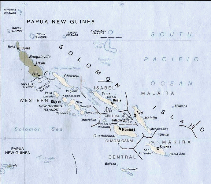
English: Map of Solomon Islands.
According to the University of Texas, "most of the maps scanned by the University of Texas Libraries and served from this web site are in the public domain. No permissions are needed to copy them. You may download them and use them as you wish. A few maps are copyrighted, and are clearly marked as such.". As the image, when downloaded from here was no tagged, the map is PD. Insofar the battle annotation make this necessary, I put this image in the public domain as well. |
| Date | |
| Source | Modified version of Solomon Islands (Political) 1989 from Perry-Castañeda Library Map Collection: Solomon Islands Maps. |
| Auteur | U.S. Central Intelligence Agency |
| Autorisation (Réutilisation de ce fichier) |
Public domain |
| Autres versions | File:New georgia pol89.jpg |
Conditions d’utilisation
| Cette image est une œuvre d'un employé de la Central Intelligence Agency, réalisée dans le cadre des tâches officielles de cette personne. En tant qu’œuvre du Gouvernement des États-Unis d'Amérique, ce document est placé dans le domaine public aux États-Unis d'Amérique.
|

|
Historique du fichier
Cliquer sur une date et heure pour voir le fichier tel qu'il était à ce moment-là.
| Date et heure | Vignette | Dimensions | Utilisateur | Commentaire | |
|---|---|---|---|---|---|
| actuel | 26 juillet 2006 à 19:18 | | 690 × 600 (176 kio) | Bradipus | |
| 11 août 2005 à 22:23 |  | 690 × 600 (68 kio) | Bradipus | Solomon Islands. Maps from http://www.lib.utexas.edu/maps/ Public Domain (see http://navalhistory.flixco.info/H/118421x19817/8330/a0.htm) {{PD}} |
Utilisation du fichier
Les 2 pages suivantes utilisent ce fichier :
Usage global du fichier
Les autres wikis suivants utilisent ce fichier :
- Utilisation sur ast.wikipedia.org
- Utilisation sur cs.wikipedia.org
- Utilisation sur de.wiktionary.org
- Utilisation sur en.wikipedia.org
- Utilisation sur es.wikipedia.org
- Utilisation sur ru.wikipedia.org
- Utilisation sur tr.wiktionary.org
- Utilisation sur uk.wikipedia.org