
Fichier:Hainanincidentmap.png
Taille de cet aperçu : 765 × 600 pixels. Autres résolutions : 306 × 240 pixels | 613 × 480 pixels | 865 × 678 pixels.
Fichier d’origine (865 × 678 pixels, taille du fichier : 45 kio, type MIME : image/png)
Ce fichier et sa description proviennent de Wikimedia Commons.
Description
| Description |
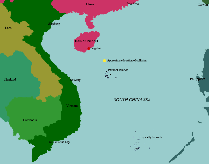
English: Map of South china sea showing location of the Hainan Island incident. Used https://web.archive.org/web/20051226191538/www.pacom.mil/imagery/archive/0104photos/010401cinc-h.jpg, File:Schina sea 88.png and Google Maps as references |
| Date | |
| Source | Travail personnel |
| Auteur | Guinnog |
Conditions d’utilisation
Moi, en tant que détenteur des droits d’auteur sur cette œuvre, je la publie sous les licences suivantes :
Ce fichier est disponible selon les termes de la licence Creative Commons Attribution – Partage dans les Mêmes Conditions 3.0 (non transposée).
- Vous êtes libre :
- de partager – de copier, distribuer et transmettre cette œuvre
- d’adapter – de modifier cette œuvre
- Sous les conditions suivantes :
- paternité – Vous devez donner les informations appropriées concernant l'auteur, fournir un lien vers la licence et indiquer si des modifications ont été faites. Vous pouvez faire cela par tout moyen raisonnable, mais en aucune façon suggérant que l’auteur vous soutient ou approuve l’utilisation que vous en faites.
- partage à l’identique – Si vous modifiez, transformez, ou vous basez sur cette œuvre, vous devez distribuer votre contribution sous la même licence ou une licence compatible avec celle de l’original.

|
Vous avez la permission de copier, distribuer et modifier ce document selon les termes de la GNU Free Documentation License version 1.2 ou toute version ultérieure publiée par la Free Software Foundation, sans sections inaltérables, sans texte de première page de couverture et sans texte de dernière page de couverture. Un exemplaire de la licence est inclus dans la section intitulée GNU Free Documentation License. |
Vous pouvez choisir l’une de ces licences.
Historique du fichier
Cliquer sur une date et heure pour voir le fichier tel qu'il était à ce moment-là.
| Date et heure | Vignette | Dimensions | Utilisateur | Commentaire | |
|---|---|---|---|---|---|
| actuel | 5 avril 2009 à 11:59 | | 865 × 678 (45 kio) | Guinnog | added islands |
| 5 avril 2009 à 06:47 |  | 865 × 678 (41 kio) | Guinnog | Cleanup, add missing caption | |
| 5 avril 2009 à 04:42 |  | 865 × 678 (50 kio) | Guinnog | {{Information |Description={{en|1=Map of South china sea showing location of the Hainan Island incident. Used http://web.archive.org/web/20051226191538/www.pacom.mil/imagery/archive/0104photos/010401cinc-h.jpg and Google Maps as references}} |Source=Own w |
Utilisation du fichier
La page suivante utilise ce fichier :
Usage global du fichier
Les autres wikis suivants utilisent ce fichier :
- Utilisation sur ar.wikipedia.org
- Utilisation sur en.wikipedia.org
- Utilisation sur es.wikipedia.org
- Utilisation sur ja.wikipedia.org
- Utilisation sur ko.wikipedia.org
- Utilisation sur www.wikidata.org