
Fichier:Map of Ontario NORTHERN.svg

Taille de cet aperçu PNG pour ce fichier SVG : 340 × 330 pixels. Autres résolutions : 247 × 240 pixels | 495 × 480 pixels | 791 × 768 pixels | 1 055 × 1 024 pixels | 2 110 × 2 048 pixels.
Fichier d’origine (Fichier SVG, nominalement de 340 × 330 pixels, taille : 83 kio)
Ce fichier et sa description proviennent de Wikimedia Commons.
Description
Cette image vectorielle non W3C-spécifiée a été créée avec Inkscape .
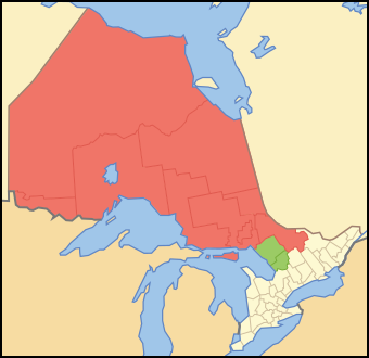
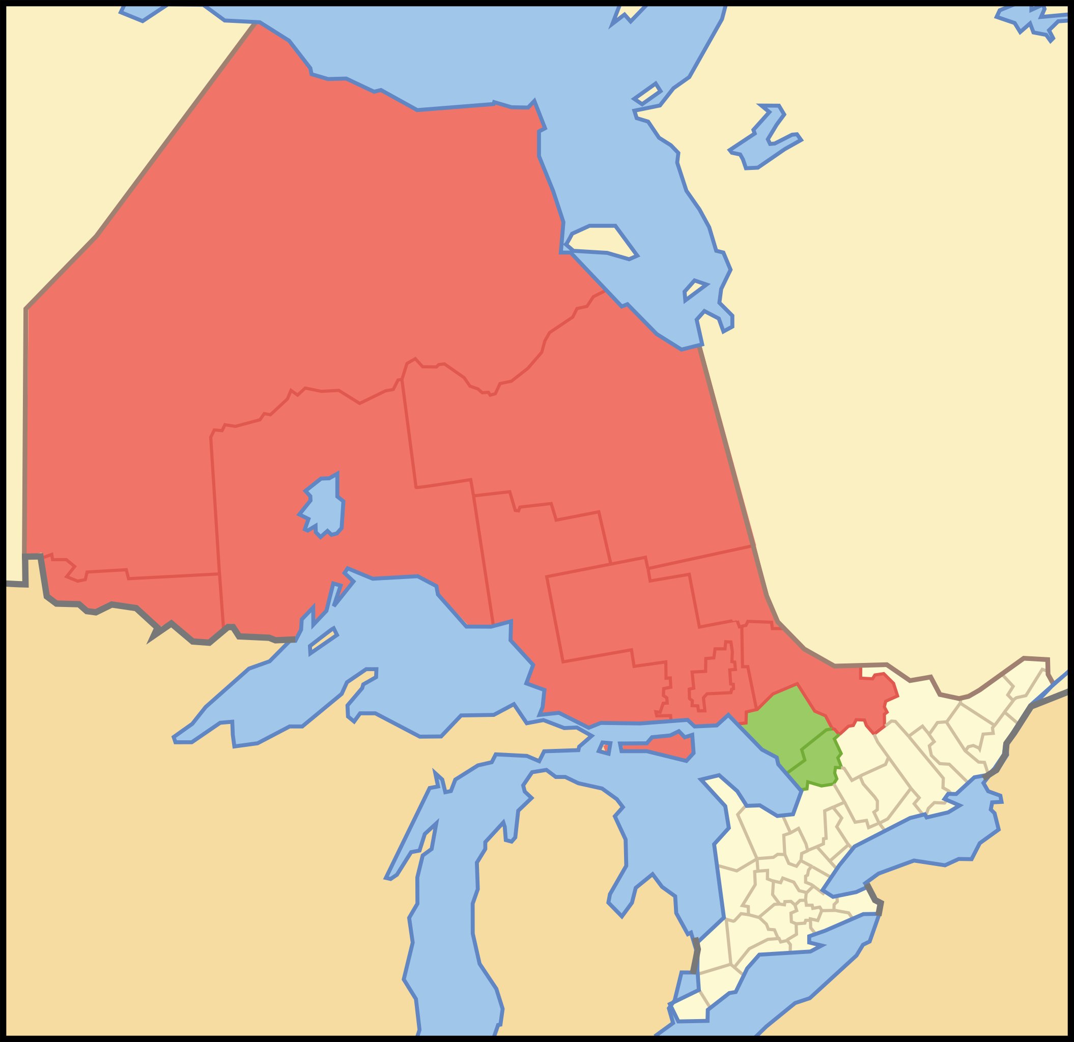
| Description | Map showing en:Northern Ontario. Red is the districts always considered Northern Ontario. Green are the districts sometimes considered Northern Ontario. |
| Date | |
| Source | Crop and trace of Image:Canada (geolocalisation).svg; trace of Image:Ontario subdivisions.PNG. |
| Auteur | Vidioman |
| Autres versions | Image:Noront.PNG, Image:Northern Ontario Map Green.png |
.svg)
Conditions d’utilisation
| Moi, propriétaire des droits d’auteur sur cette œuvre, la place dans le domaine public. Ceci s'applique dans le monde entier. Dans certains pays, ceci peut ne pas être possible ; dans ce cas : J’accorde à toute personne le droit d’utiliser cette œuvre dans n’importe quel but, sans aucune condition, sauf celles requises par la loi. |
Historique du fichier
Cliquer sur une date et heure pour voir le fichier tel qu'il était à ce moment-là.
| Date et heure | Vignette | Dimensions | Utilisateur | Commentaire | |
|---|---|---|---|---|---|
| actuel | 12 octobre 2007 à 14:03 | | 340 × 330 (83 kio) | Vidioman | {{Created with Inkscape}} {{Information |Description=Map showing Northern Ontario. Red is the districts always considered Northern Ontario. Green are the districts sometimes considered Northern Ontario. |Source=Crop and trace of [[:Image:Canada (geolocali |
Utilisation du fichier
La page suivante utilise ce fichier :
Usage global du fichier
Les autres wikis suivants utilisent ce fichier :
- Utilisation sur en.wikipedia.org
- Northern Ontario
- Abitibi Canyon
- Acanthus, Ontario
- Achray, Ontario
- Adanac, Nipissing District, Ontario
- Unorganized South Nipissing District
- Whitefish Lake 6, Ontario
- Centennial Park (Thunder Bay)
- Lake Manitou
- Sturgeon Falls
- Kiosk, Ontario
- Estaire, Ontario
- Kukatush, Ontario
- Prince, Ontario
- Cedar Lake (Nipissing District)
- Red Cedar Lake (Ontario)
- Wabigoon Lake
- Spence, Ontario
- Unorganized Kenora District
- Papineau-Cameron
- Calvin, Ontario
- Bridal Veil Falls (Manitoulin Island)
- Unorganized North Nipissing District
- Thunder Bay (Ontario)
- Balsam Creek, Ontario
- Bear Island (Lake Temagami)
- Evanturel
- Tidewater Provincial Park
- Template:NorthernOntario-geo-stub
- Sudbury Downs
- Marten River, Ontario
- Chisholm, Ontario
- La Verendrye Provincial Park
- Opeongo River Provincial Park
- Sultan, Ontario
- Aroland First Nation
- Osnaburgh 63A
- Lount Township, Ontario
- Hollinger Park
- Ryerson, Ontario
- Joly, Ontario
- Burpee and Mills
- False Detour Channel
- Mississagi Strait
- Goat Island (Ontario)
- Maynard Lake
- Lac Seul
- Whitewater Lake
- Paradis Bay, Ontario
- Ojibway Provincial Park
Voir davantage sur l’utilisation globale de ce fichier.