
Fichier:OIC countries map.png

Taille de cet aperçu : 800 × 338 pixels. Autres résolutions : 320 × 135 pixels | 640 × 270 pixels | 1 480 × 625 pixels.
Fichier d’origine (1 480 × 625 pixels, taille du fichier : 43 kio, type MIME : image/png)
Ce fichier et sa description proviennent de Wikimedia Commons.
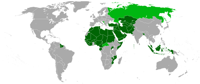
- Karte der Mitgliedsstaaten (dunkelgrün) und Beobachterstaaten (hellgrün) der Organisation der Islamischen Konferenz OIC
- Map of the member and observer states of the Organisation of the Islamic Conference OIC
Source
- Upload on http://de.wikipedia.org
- 01:09, 29. Jul 2005 . . St.Krekeler . . 969 x 579 (20772 Byte)

|
Vous avez la permission de copier, distribuer et modifier ce document selon les termes de la GNU Free Documentation License version 1.2 ou toute version ultérieure publiée par la Free Software Foundation, sans sections inaltérables, sans texte de première page de couverture et sans texte de dernière page de couverture. Un exemplaire de la licence est inclus dans la section intitulée GNU Free Documentation License. |
| Ce fichier est disponible selon les termes de la licence Creative Commons Attribution – Partage dans les Mêmes Conditions 3.0 (non transposée). | ||
| ||
| Ce bandeau de licence a été ajouté à ce fichier dans le cadre de la procédure de mise à jour des licences des images sous GFDL. |

|
Cette image (de type organization map) devrait être recréée dans un format vectoriel, en tant que fichier SVG. Cela offrirait plusieurs avantages : voir Commons:Media for cleanup pour plus d'informations. Si une version SVG de cette image est déjà disponible, merci de bien vouloir l'envoyer. Après cela, remplacez ce modèle par {{vector version available|nouveau nom d'image.svg}}.
|
| Annotations | Cette image est annotée : Voir les annotations sur Wikimedia Commons |
Historique du fichier
Cliquer sur une date et heure pour voir le fichier tel qu'il était à ce moment-là.
| Date et heure | Vignette | Dimensions | Utilisateur | Commentaire | |
|---|---|---|---|---|---|
| actuel | 2 février 2018 à 23:49 | | 1 480 × 625 (43 kio) | Maphobbyist | Added Maldives which is an OIC member and was forgotten. |
| 2 février 2018 à 23:45 |  | 1 480 × 625 (43 kio) | Maphobbyist | Added borders of South Sudan which became independent in 2011 and which is not a member of the OIC. | |
| 1 janvier 2018 à 20:05 |  | 1 480 × 625 (22 kio) | Nameless23 | Added missing western part of Malaysia | |
| 12 juin 2013 à 14:55 |  | 1 480 × 625 (32 kio) | Excolis | Maybe it works now | |
| 12 juin 2013 à 14:53 |  | 1 480 × 625 (32 kio) | Excolis | Now with Northern Cyprus as a light green marked state on the map. | |
| 26 janvier 2011 à 17:17 |  | 1 480 × 625 (62 kio) | Kaiserslautern1993 | ||
| 26 janvier 2011 à 17:06 |  | 1 480 × 625 (62 kio) | Kaiserslautern1993 | ||
| 15 septembre 2008 à 19:02 |  | 1 357 × 628 (32 kio) | Milosevo | + Beobachter, + transparent background | |
| 21 février 2008 à 23:29 |  | 1 357 × 628 (88 kio) | Leavade | Sahara hasn't signed | |
| 29 janvier 2008 à 15:33 |  | 1 357 × 628 (52 kio) | Tariqhada | Reverted to version as of 17:09, 15 November 2007 |
Utilisation du fichier
Les 2 pages suivantes utilisent ce fichier :
Usage global du fichier
Les autres wikis suivants utilisent ce fichier :
- Utilisation sur als.wikipedia.org
- Utilisation sur ar.wikipedia.org
- Utilisation sur eo.wikipedia.org
- Utilisation sur hr.wikipedia.org
- Utilisation sur ja.wikipedia.org
- Utilisation sur wo.wikipedia.org