
Fichier:Paricutin 30 612.jpg

Taille de cet aperçu : 400 × 600 pixels. Autres résolutions : 160 × 240 pixels | 320 × 480 pixels | 667 × 1 000 pixels.
Fichier d’origine (667 × 1 000 pixels, taille du fichier : 53 kio, type MIME : image/jpeg)
Ce fichier et sa description proviennent de Wikimedia Commons.
Description
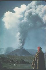
| Description | This slide shows the cinder cone soon after its birth in 1943 in a Mexican cornfield. During its brief nine-year lifespan (1943-1952), it built a 410-meter-high cone with extensive lava fields around the base of the cone. Most of the 2 km3 of eruptive products (ash, cinders, and lava) were produced in the first few years. Cinder cones such as this one are commonly formed by one eruption. Each subsequent eruption in the same area forms its own cinder cone. |
| Date | |
| Source | http://www.ngdc.noaa.gov/seg/hazard/slideset/30/30_612_slide.shtml |
| Auteur | Photo credit: K. Segerstrom, U.S. Geological Survey |
| Autorisation (Réutilisation de ce fichier) |
PD-USGov-NOAA |
Cette image est dans le domaine public car son contenu provient de la
National Oceanic and Atmospheric Administration , réalisé par un employé dans le cadre de ses activités professionnelles.
|
Historique du fichier
Cliquer sur une date et heure pour voir le fichier tel qu'il était à ce moment-là.
| Date et heure | Vignette | Dimensions | Utilisateur | Commentaire | |
|---|---|---|---|---|---|
| actuel | 17 octobre 2006 à 22:31 | | 667 × 1 000 (53 kio) | Alhen | {{Information |Description= Paricutin, Mexico;19.48 N 102.25 W;3,170 m elevation This slide shows the cinder cone soon after its birth in 1943 in a Mexican cornfield. During its brief nine-year lifespan (1943-1952), it built a 410-mete |
| 17 octobre 2006 à 22:18 |  | 667 × 1 000 (49 kio) | Alhen | {{Information |Description= w:Paricutin, Mexico;19.48 N 102.25 W;3,170 m elevation This slide shows the cinder cone soon after its birth in 1943 in a Mexican cornfield. During its brief nine-year lifespan (1943-1952), it built a 410-meter-high co |
Utilisation du fichier
Les 2 pages suivantes utilisent ce fichier :
Usage global du fichier
Les autres wikis suivants utilisent ce fichier :
- Utilisation sur ar.wikipedia.org
- Utilisation sur ast.wikipedia.org
- Utilisation sur ca.wikipedia.org
- Utilisation sur de.wikipedia.org
- Utilisation sur dv.wikipedia.org
- Utilisation sur el.wikipedia.org
- Utilisation sur en.wikipedia.org
- Utilisation sur en.wikibooks.org
- Utilisation sur es.wikipedia.org
- Utilisation sur fa.wikipedia.org
- Utilisation sur hu.wikipedia.org
- Utilisation sur it.wikipedia.org
- Utilisation sur ja.wikipedia.org
- Utilisation sur ko.wikipedia.org
- Utilisation sur lt.wikipedia.org
- Utilisation sur mk.wikipedia.org
- Utilisation sur mr.wikipedia.org
- Utilisation sur nah.wikipedia.org
- Utilisation sur nn.wikipedia.org
- Utilisation sur no.wikipedia.org
- Utilisation sur oc.wikipedia.org
- Utilisation sur pl.wikipedia.org
- Utilisation sur ro.wikipedia.org
- Utilisation sur ru.wikipedia.org
- Utilisation sur sh.wikipedia.org
- Utilisation sur tr.wikipedia.org
- Utilisation sur uk.wikipedia.org