
Fichier:River Mole Map.png
Pas de plus haute résolution disponible.
River_Mole_Map.png (447 × 544 pixels, taille du fichier : 67 kio, type MIME : image/png)
Ce fichier et sa description proviennent de Wikimedia Commons.
Description
| Description |
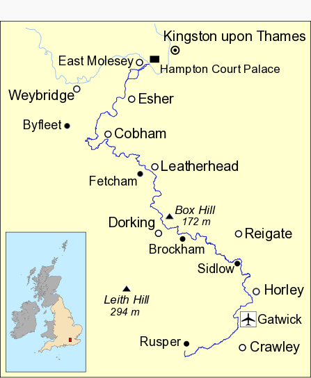
English: Map of River Mole in south east England showing part of the River Thames. Data from Open Street Maps. |
| Date | |
| Source | Travail personnel |
| Auteur | Mertbiol |
| Autres versions | River Mole Map.svg |
Conditions d’utilisation
| Moi, propriétaire des droits d’auteur sur cette œuvre, la place dans le domaine public. Ceci s'applique dans le monde entier. Dans certains pays, ceci peut ne pas être possible ; dans ce cas : J’accorde à toute personne le droit d’utiliser cette œuvre dans n’importe quel but, sans aucune condition, sauf celles requises par la loi. |
Historique du fichier
Cliquer sur une date et heure pour voir le fichier tel qu'il était à ce moment-là.
| Date et heure | Vignette | Dimensions | Utilisateur | Commentaire | |
|---|---|---|---|---|---|
| actuel | 8 octobre 2010 à 16:25 | | 447 × 544 (67 kio) | Mertbiol | Sort out colouring and make rivers bolder. |
| 17 février 2010 à 17:18 |  | 447 × 544 (67 kio) | Mertbiol | Add Leith Hill and Box Hill. | |
| 17 février 2010 à 15:22 |  | 447 × 544 (62 kio) | Mertbiol | Make UK map smaller and tweak town/village label positions. | |
| 17 février 2010 à 14:30 |  | 447 × 544 (65 kio) | Mertbiol | Sort out grey area at top for correct display in infobox | |
| 17 février 2010 à 13:55 |  | 447 × 544 (65 kio) | Mertbiol | Change text sizes to fit info box better. | |
| 14 février 2010 à 21:41 |  | 447 × 514 (68 kio) | Mertbiol | Smarten up border and general minor tweaks. | |
| 14 février 2010 à 19:52 |  | 450 × 515 (68 kio) | Mertbiol | Add border and put Weybridge and Byfleet on map. | |
| 14 février 2010 à 18:09 |  | 450 × 515 (62 kio) | Mertbiol | Add Horley to map | |
| 14 février 2010 à 17:51 |  | 450 × 515 (60 kio) | Mertbiol | {{Information |Description={{en|1=Map of River Mole in south east England showing part of the River Thames}} |Source={{own}} |Author=Mertbiol |Date=2010-02-14 |Permission= |other_versions=River Mole Map.svg }} Category:Surrey |
Utilisation du fichier
La page suivante utilise ce fichier :
Usage global du fichier
Les autres wikis suivants utilisent ce fichier :
- Utilisation sur en.wikipedia.org
- Utilisation sur fi.wikipedia.org
- Utilisation sur nn.wikipedia.org
- Utilisation sur no.wikipedia.org