
Fichier:The facade of the the Tomb of the Palmettes, first half of the 3rd century BC, Ancient Mieza (7263674714).jpg

Taille de cet aperçu : 450 × 600 pixels. Autres résolutions : 180 × 240 pixels | 360 × 480 pixels | 576 × 768 pixels | 768 × 1 024 pixels | 1 536 × 2 048 pixels | 3 216 × 4 288 pixels.
Fichier d’origine (3 216 × 4 288 pixels, taille du fichier : 10,87 Mio, type MIME : image/jpeg)
Ce fichier et sa description proviennent de Wikimedia Commons.
.jpg?uselang=fr)
Description
| Description |
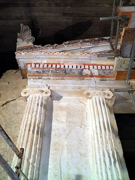
The entrance has crowning mouldings on the interior sides, decorated by coloured Doric and Ionic mouldings and taeniae. There was no dromos leading to the tomb. The present staircase is a modern structure, designed to facilitate visitors and also to support the natural side walls of the excavated trench and prevent the monument from being covered with earth once again. Dimensions of the antechamber: lengh 2, width 408, heigh 5.14m ; dimensions of the main chamber: lengh 5.10, width 4.07, height 4.95m. The facade is 6.25m high, 5.25m wide, and is higher than the roof. The predominant colour on the facade up to the level of the capitals of the Ionic half-columns is white; this is the final thin layer of lime-plaster which was used according to the prevailing custom to cover the surface of the poros blocks, which was full of holes, and make it look like marble. From the level of the capitals upwards a variety of colours is used, the predominant ones being shades of red and blue applied to the individual decorative elements: Ionic and Doric mouldings, frieze, taeniaeeeeem astragals, Lesbian mouldings, and alternating palmettes and lotus flowers, which adorned the raking of the tympanum of the pediment of the Ionic architrave. The pediment ont the facade is crowned by three windblown palmettes with a strong chiaroscuro effect, produced by the deep relief of the leaves and the triangular tongue-heart at its center, with deep blue between the white-ochre and slightly pink leaves, and deep pink and red at the heart in the centre. |
| Date | |
| Source |
The facade of the the Tomb of the Palmettes, first half of the 3rd century BC, Ancient Mieza
|
| Auteur | Carole Raddato from FRANKFURT, Germany |
| Lieu de la prise de vue | | Voir cet endroit et d’autres images sur : OpenStreetMap |
|---|
.jpg¶ms=040.651471_N_0022.116680_E_globe:Earth_type:camera_source:Flickr_&language=fr)
Conditions d’utilisation
Ce fichier est disponible selon les termes de la licence Creative Commons Attribution – Partage dans les Mêmes Conditions 2.0 Générique
- Vous êtes libre :
- de partager – de copier, distribuer et transmettre cette œuvre
- d’adapter – de modifier cette œuvre
- Sous les conditions suivantes :
- paternité – Vous devez donner les informations appropriées concernant l'auteur, fournir un lien vers la licence et indiquer si des modifications ont été faites. Vous pouvez faire cela par tout moyen raisonnable, mais en aucune façon suggérant que l’auteur vous soutient ou approuve l’utilisation que vous en faites.
- partage à l’identique – Si vous modifiez, transformez, ou vous basez sur cette œuvre, vous devez distribuer votre contribution sous la même licence ou une licence compatible avec celle de l’original.
| Cette image, qui provient de Flickr, a été vérifiée le 15 décembre 2013 par l'administrateur ou l'utilisateur de confiance (trusted user) File Upload Bot (Magnus Manske), qui a confirmé qu'à cette date, elle était publiée sur Flickr sous cette licence. |
Ce document est dans le domaine public aux États-Unis. Ceci s'applique aux travaux des États-Unis où le copyright a expiré, souvent parce que sa première publication s'est produite avant le 1er janvier 1929. Voir cette page pour davantage d'explication.
|
 | |
 |
Cette image peut ne pas être dans le domaine public en dehors des États-Unis (ceci s'applique particulièrement au Canada, en Chine (pas Hong Kong, Macao, ni Taïwan), en Allemagne ou en Suisse). Le créateur et l'année de la publication sont l'information essentielle et doivent être fournis.
|
|
Cette œuvre est également dans le domaine public dans tous les pays pour lesquels le droit d’auteur a une durée de vie de 100 ans ou moins après la mort de l’auteur. | |
| Ce fichier a été identifié comme étant exempt de restrictions connues liées au droit d’auteur, y compris tous les droits connexes et voisins. | |
Historique du fichier
Cliquer sur une date et heure pour voir le fichier tel qu'il était à ce moment-là.
| Date et heure | Vignette | Dimensions | Utilisateur | Commentaire | |
|---|---|---|---|---|---|
| actuel | 15 décembre 2013 à 14:37 | | 3 216 × 4 288 (10,87 Mio) | File Upload Bot (Magnus Manske) | Transferred from Flickr by User:Marcus Cyron |
Utilisation du fichier
La page suivante utilise ce fichier :
Usage global du fichier
Les autres wikis suivants utilisent ce fichier :
- Utilisation sur en.wikipedia.org
- Utilisation sur id.wikipedia.org
- Utilisation sur mk.wikipedia.org
- Utilisation sur vi.wikipedia.org
.jpg)