
Fichier:US Court of Appeals and District Court map.svg

Taille de cet aperçu PNG pour ce fichier SVG : 620 × 402 pixels. Autres résolutions : 320 × 207 pixels | 640 × 415 pixels | 1 024 × 664 pixels | 1 280 × 830 pixels | 2 560 × 1 660 pixels.
Fichier d’origine (Fichier SVG, nominalement de 620 × 402 pixels, taille : 768 kio)
Ce fichier et sa description proviennent de Wikimedia Commons.
Description
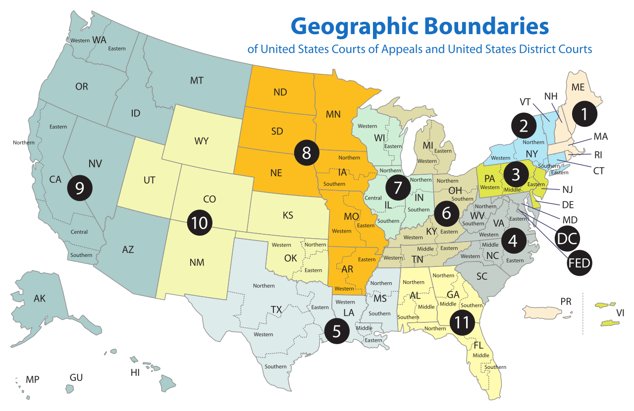
| Description | Map of the geographic boundaries of the various United States courts of appeals and United States district courts. |
| Date | |
| Source | http://www.uscourts.gov/uscourts/images/CircuitMap.pdf |
| Auteur | PDF by the US Government, converted using Texterity's FreeSVG, tweaked using en:Inkscape by Tintazul |
| Autres versions |
|


Conditions d’utilisation
This work is licensed by the creator under the following conditions:
Ce fichier est disponible selon les termes de la licence Creative Commons Attribution – Partage dans les Mêmes Conditions 2.5 Générique
- Vous êtes libre :
- de partager – de copier, distribuer et transmettre cette œuvre
- d’adapter – de modifier cette œuvre
- Sous les conditions suivantes :
- paternité – Vous devez donner les informations appropriées concernant l'auteur, fournir un lien vers la licence et indiquer si des modifications ont été faites. Vous pouvez faire cela par tout moyen raisonnable, mais en aucune façon suggérant que l’auteur vous soutient ou approuve l’utilisation que vous en faites.
- partage à l’identique – Si vous modifiez, transformez, ou vous basez sur cette œuvre, vous devez distribuer votre contribution sous la même licence ou une licence compatible avec celle de l’original.
The original work from which this is derived is in the public domain for the following reason:
This image is a work of a United States Department of Justice employee, taken or made as part of that person's official duties. As a work of the U.S. federal government, the image is in the public domain (17 U.S.C. § 101 and 105).
|
 |
Historique du fichier
Cliquer sur une date et heure pour voir le fichier tel qu'il était à ce moment-là.
| Date et heure | Vignette | Dimensions | Utilisateur | Commentaire | |
|---|---|---|---|---|---|
| actuel | 17 avril 2018 à 20:58 | | 620 × 402 (768 kio) | BenbowInn | DC and FED are circuits too, added black circles to emphasize them, also converted to plain SVG |
| 11 juillet 2006 à 09:48 |  | 620 × 402 (1,14 Mio) | Tintazul | {{Tintazul |Description=Map of the geographic boundaries of the various United States Courts of Appeals and United States District Courts. |Source=[http://www.uscourts.gov/image |
Utilisation du fichier
Les 4 pages suivantes utilisent ce fichier :
Usage global du fichier
Les autres wikis suivants utilisent ce fichier :
- Utilisation sur ar.wikipedia.org
- Utilisation sur bg.wikipedia.org
- Utilisation sur bn.wikipedia.org
- Utilisation sur ca.wikipedia.org
- Utilisation sur ckb.wikipedia.org
- Utilisation sur cs.wikipedia.org
- Utilisation sur da.wikipedia.org
- Utilisation sur de.wikipedia.org
- Utilisation sur en.wikipedia.org
- Federal jurisdiction (United States)
- United States courts of appeals
- United States district court
- United States federal judicial district
- United States Court of Appeals for the Ninth Circuit
- United States Court of Appeals for the Eighth Circuit
- Case citation
- List of regions of the United States
- United States Court of Appeals for the First Circuit
- United States Court of Appeals for the Second Circuit
- United States Court of Appeals for the Third Circuit
- United States Court of Appeals for the Fourth Circuit
- United States Court of Appeals for the Fifth Circuit
- United States Court of Appeals for the Sixth Circuit
- United States Court of Appeals for the Seventh Circuit
- United States Court of Appeals for the Tenth Circuit
- United States Court of Appeals for the Eleventh Circuit
- United States Attorney
- United States Court of Appeals for the District of Columbia Circuit
- Circuit court
- United States District Court for the Southern District of New York
- United States District Court for the Eastern District of Virginia
- United States District Court for the Eastern District of Pennsylvania
- United States District Court for the Central District of California
- List of former United States district courts
- United States District Court for the Western District of New York
- United States District Court for the Eastern District of New York
- United States District Court for the Northern District of New York
- United States District Court for the Middle District of Alabama
- United States District Court for the Southern District of Alabama
- United States District Court for the Northern District of Alabama
- United States District Court for the Southern District of California
- United States District Court for the Southern District of Florida
Voir davantage sur l’utilisation globale de ce fichier.